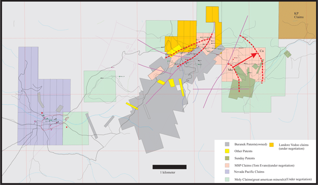
The Spruce Mountain molybdenum-silver porphyry project is located in North Eastern Nevada, USA, about 40 miles south of Wells, 25 miles north of the town of Currie. It is a prospective property for molybdenum, with copper, silver, gold and rhenium by-products. The property is located in the Spruce Mountain lead-silver mining district. To date, approximately $5 million worth of lead and silver has been mined at the location from four lead/silver mines contained within the property. These are the Monarch, Black Forest, Kille and Spruce Standard Mines. The location has good accessibility year round with good quality gravel roads and railway lines within 25 miles of the property.
Currently, CuMoCo is focusing its resources on advancing the CuMo Project and Calida Gold. The Spruce Mountain project will benefit from the CuMoCo’s expert leadership when exploration and development becomes a company priority.
Click map on the right for larger view.

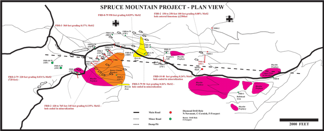
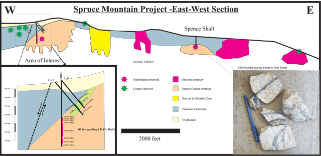
Spruce Mountain has been known for many years to host significant lead-silver mineralization which was mined between 1869 and the late 1930’s. In 1977, during exploration for more lead-silver mineralization, Freeport Exploration Company discovered molybdenum-silver mineralization associated with a large intrusion known as the Spence Porphyry. Several significant intersections were obtained between 1977 and 1982 including a small diamond and rotary hole drilling program by Amax. However, with low molybdenum prices the property was returned to the original owners. In 1984 Santa Fe mining optioned the property having become interested in the gold potential of the nearby Pilot Shale and by the end of 1985 had drilled 25 holes totaling 10,000 feet. This exploration encountered gold bearing quartz stockwork veins up to 80 feet thick. Santa Fe however, felt the drilling had not proven up sufficient mineralization for further work and dropped the option.
Examination of the results from previous exploration indicates that two of the recommended holes that were never drilled are required in order to properly understand the geometry and extent of the molybdenum bearing system.
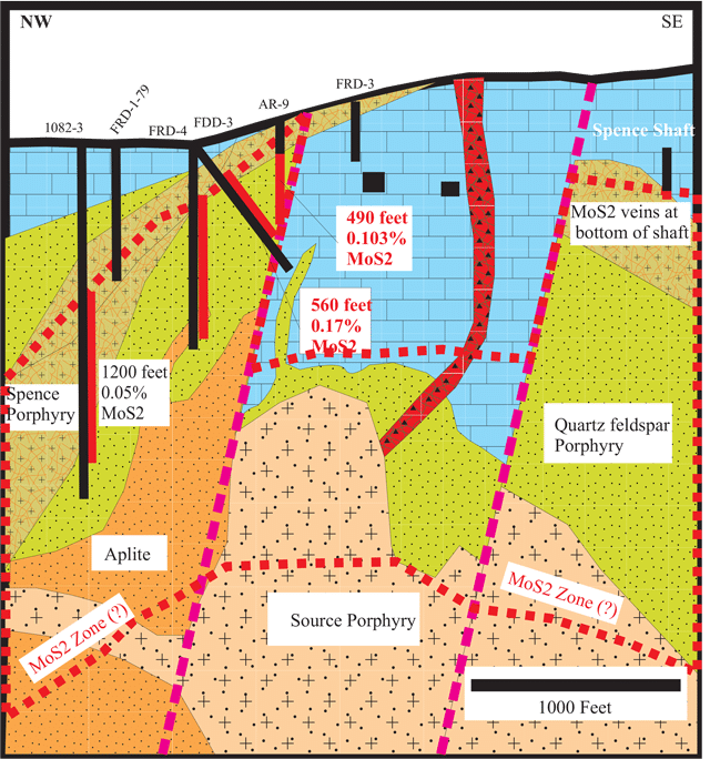
Drill intersections from the 1980’s that were never properly followed up include:
| Hole | FDD-3 | 170.7 meters (560 feet) | grading 0.170% MoS2. |
| Hole | FRD-2 | 105.2 meters (345 feet) | grading 0.135%MoS2. |
| Hole | 1082-3 | 365.8 meters (1200 feet) | grading 0.050%MoS2. |
| Hole | Ar-7 | 210.3 meters (690 feet) | grading 0.058%MoS2. |
| Hole | Ar-9 | 149.4 meters (490 feet) | grading 0.103%MoS2. |


The Spruce Mountain property lay dormant for many years before CuMoCo purchased the core patent claims covering the main portion of the mineralized zones in 2006. The claims include both the mineral and surface rights.
